#Dronestrategy What should you know to fly in Spain and Islands
12Next >
37011 61 2019-4-4
Uploading and Loding Picture ...(0/1)
o(^-^)o
ParideM
Captain
Flight distance : 6103757 ft
  • >>>
Switzerland
Offline

Location: Majorca island, Fuerteventura and Lanzarote islands.
Time: May and december 2018, personally only not commercial flight.
DJI Drone: Mavic Air, Mavic 2 pro

Premise:
In my two trips to the Spanish islands I used AirMap to verify that in the area where I intended to fly the use of drones was allowed.
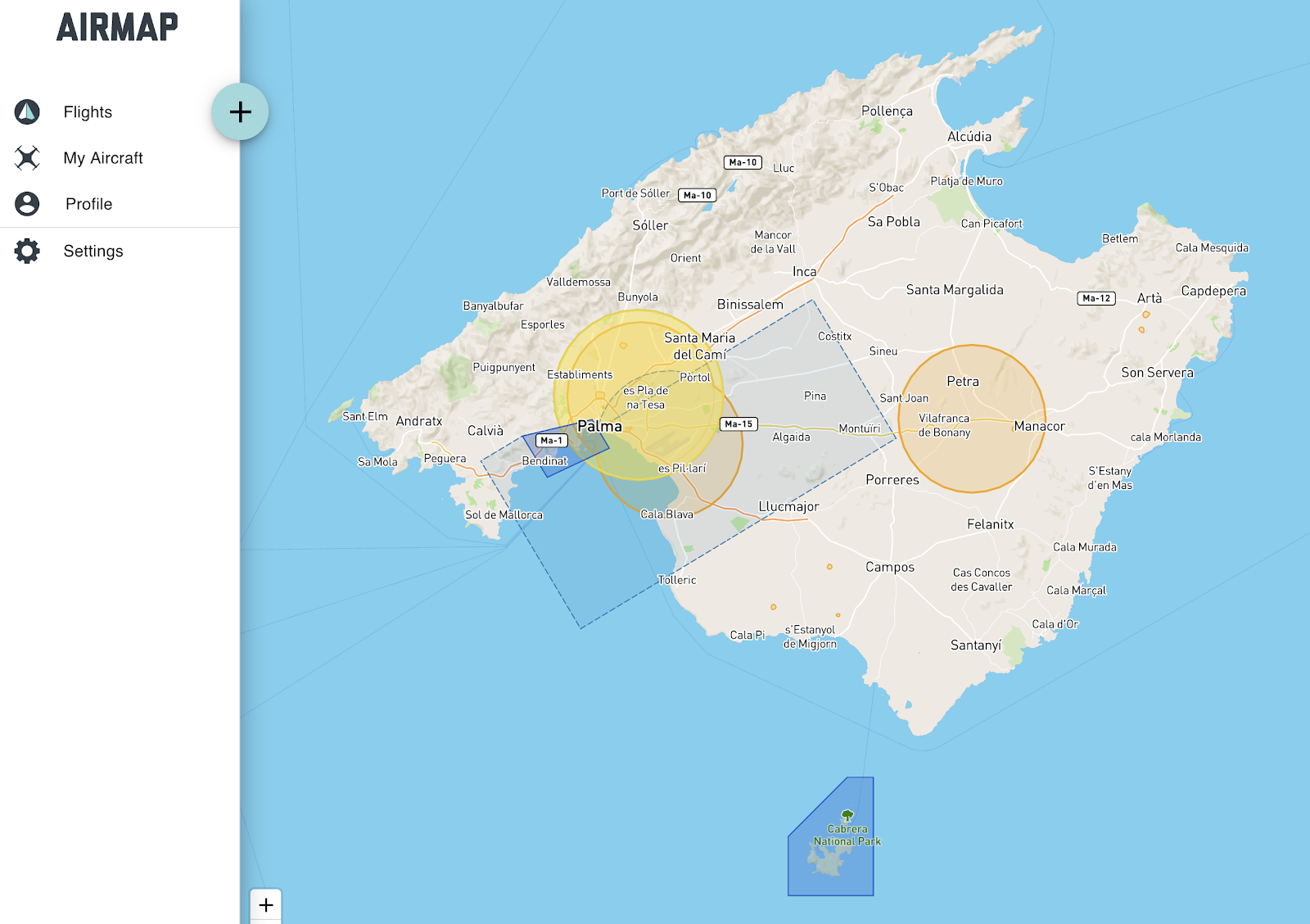
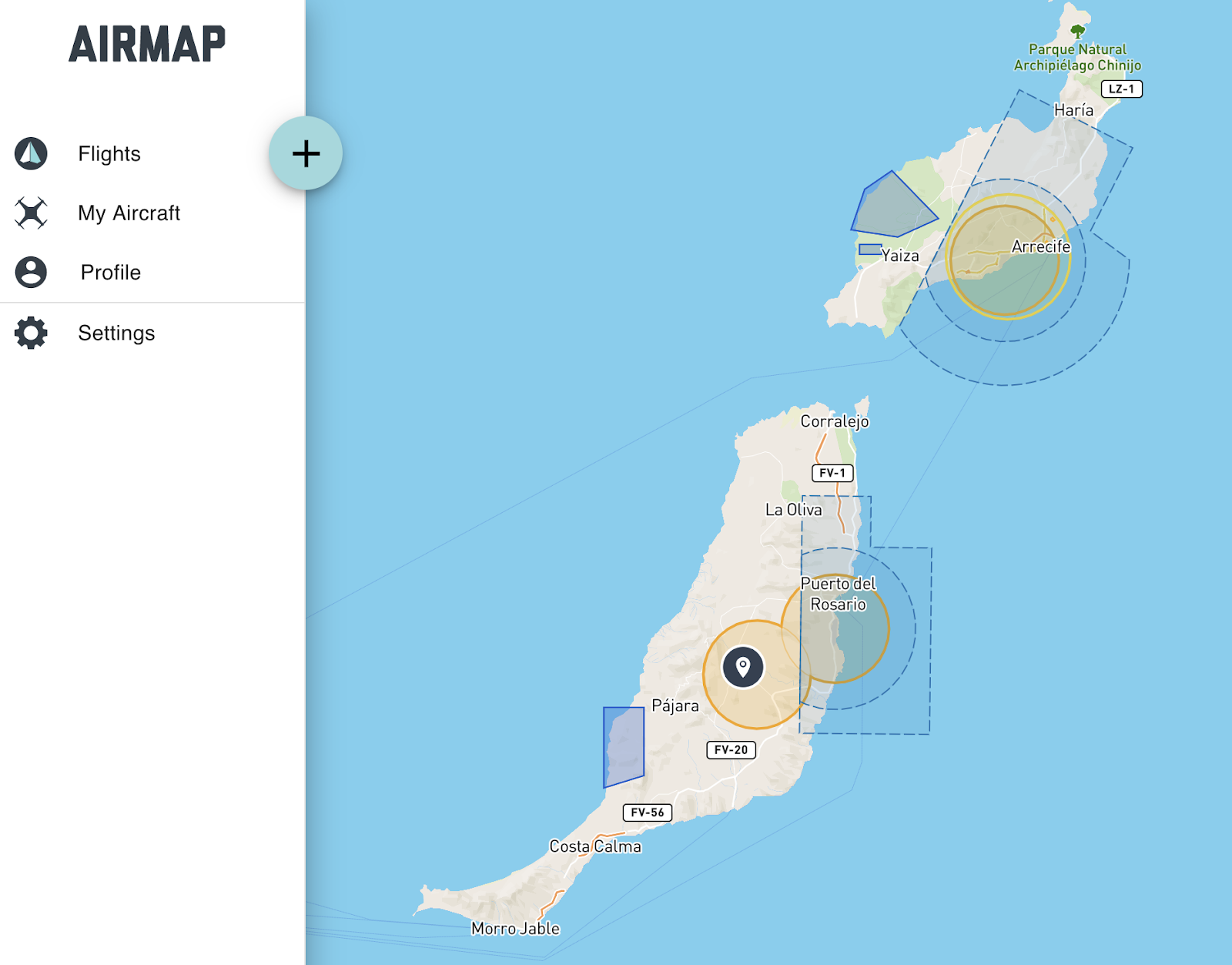
When I went to Majorca, Fuerteventura and Lanzarote I was not aware that some, and in the case of Lanzarote most of the areas where I flew, were actually banned because they were protected areas or areas forbidden to photographic flight, or as in the case of Pollença within a military area.
As you can see from the maps below, the reality is quite different.

Majorca island

Fuerteventura and Lanzarote islands
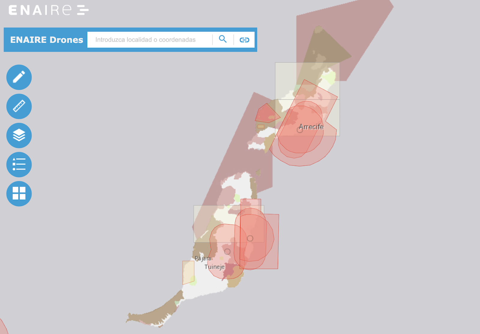
If you go to Spain or to one of its islands, always use the official map only, I will do the same in the future. Enaire Map

How I plan my travels:
When I decide to travel, first of all I get information about the laws governing the use of drones and the permitted and prohibited areas.
I search on the internet for places to visit and I create a map on Google MyMaps by entering the coordinates.
Based on the days of vacation, I take note of the air tickets and the overnight stay costs, I organize the travel.
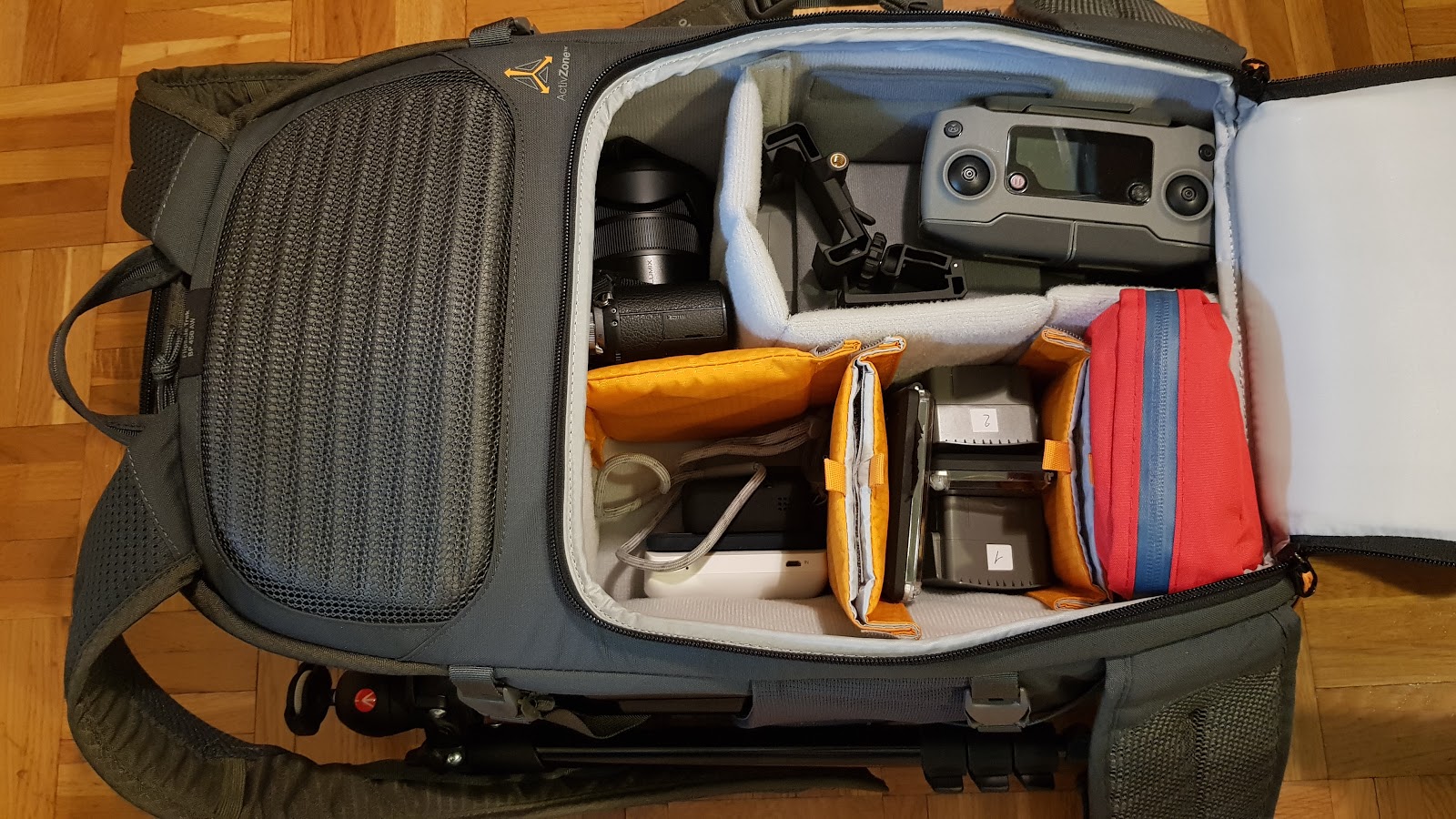
Usually in my hand luggage I carry the Drone, the GoPro, the camera from now and on, the batteries and the things that I consider important and valuable, in the hold baggage everything else. (My equipment)

Application Process:
- No application needed for recreational user if you want to fly in unrestricted areas with a drone.
Additional information for authorizations:
   -Enaire
  - Aesa

What you should prepare before traveling with a drone in Spain:
- It is better to drain batteries and place them in fireproof cases if you take the plane, some airline companies may request it. Don't put batteries in your checked-in luggage but carry them with you.

- Apply a fireproof label on the drone with your full name and phone number, it is not required for recreational but I recommend it even if you want to fly in other countries, I also applied it on my GoPro, in case of loss.

- The ‘geofencing’ functionality in DJI drones is a geographical restriction of the operational area of the drone that is specified by the manufacturer. The manufacturer’s restrictions might not be identical to the restrictions on use under the applicable national legislation. This means that you must always be aware of local flight restrictions before operating / piloting a DJI drone. Take a look to official ENAIRE MAP to verify that you can fly in determined areas.

Regulations for recreational use:

- Always keep the drone in sight in a radius of 500m (Art.21.1)

- Don't fly near airports, airfields atc.

- To become aware of a possible temporary ban.

- Don't fly in controlled airspace or where other low-altitude flights are performed.

- Daytime flying with appropriate meteorological conditions (no fog, rain or wind)

- Night-time flying with appropriate meteorological conditions (no fog, rain or wind) with a drone of up to 2kg and going no higher than 50m.

- When flying with FPV goggles, you must be accompanied by an observer.

- Do not exceed a height of 120m (400feet) and or on the highest obstacle located within a radius of 150 m from the RPA (AESA N°41).

- Do not fly in natural parcs (consult Enaire Map)

- If your drone weighs more than 250g do not fly over urban areas and people. Keep a security distance (50m) from buildings and people.

- Never fly over sensible areas like prisons, military zone, ecc.

- You must know how to fly safely and do it under supervision of an adult if you are under 18.

- You are responsible for any damage caused by your drone. You are advised to apply for a third-party insurance.

Regulations for professional use:

- Be authorised by AESA.

- Have a civil liability insurance specific for aircraft operations,

- Have valid RPAS pilot and medical certificate.

- For Flights in controlled airspace, you must have a certificate to prove that you have the required knowledge of communications and languages used between controllers and pilots.

- Depending on the MTOM of the aircraft and its mode of operation, there may be additional requirements.

- Know that the operator is responsible for the RPAS, its operation and for complying with regulations.

- Adhere to the Data Protection Act, the Law on the Right to Honour, Privacy and Personal Image, and the restrictions for taking aerial images.

- All aircraft piloted by remote control (RPA, and the control station also) must have on it a fireproof plate identification, which must contain the identification of the aircraft with their specific name, including the manufacturer's name, type, model and where appropriate , the serial number and the name of the operator and the data necessary to contact him. The information on the nameplate must be marked on it by engraving, punching, stamping or other approved method of fireproof marking in an eye - legible and indelible manner. AESA q&a N°34

- Don’t fly without authorisation:
  • over buildings and people
  • at night
  • In controlled airspace, or in close proximity to aerodromes and heliports, adhering to the distances established by law.
  • in emergencies without being instructed by the public authority

    --additional informations for professional use--


Remember:
- Do not put others at risk or disturb them (other aircraft, people or property.
- The dissemination of images of people or private spaces requires the authorisation thereof.
- Fines for improper use can amount to €225,000.  Sanctions can amount of €4.5 million for professional users.

Recommendations:
Inspect your drone before and after each flight, check the entire frame for cracks including the landing gear and props. Make sure you have sufficient GPS signal and wait for the "Home Point Recorded" message to avoid a fly away, and an adequate RTH altitude setted for a safe return to home.

Always check the weather conditions to find out about wind conditions or if you'll find rain, fog or snow. Cold and high wind drain fast your batteries, and high-altitude winds could generate a "Max motor speed reached" alert which inform you that your drone is in danger.

The “see and avoid” principle applies to unmanned aircraft as well. Since an aircraft pilot stands little chance of recognizing a small drone early enough, it is your responsibility to take timely evasive action and always to maintain a proper distance from other aircrafts.
Especially on the mountains, always fly in your line of sight, don't think to be alone all the time, helicopters and other planes you couldn't hear can come close to your drone; they often fly at low altitude leaving you a little reaction time.
Flying a drone over the scene of an accident to take aerial pictures may impede a rescue helicopter from approaching the site. In addition, rescue services feel that their work is disturbed by drones. It is forbidden to fly a drone in an emergency operation if not instructed to do so by the operation leader.

Useful tips:
Bring filters with you, especially on the mountains or if you visit lakes and beaches or you find snow, I recommend you polarized filters for reflecting surfaces (i use 32/pl also).

Bring at least two batteries with you and make sure you have an empty and capacious SD card.

Find a way to make a daily backup of your footages; personally I use a backup unit with a SSD.

Bring a landing pad or landing gear and an outdoor first aid kit with you if you want to go hiking on the mountains and don't forget photography gloves in winter time and your sunglasses!

Official links:
- Official Spain map restrictions for drones (Enaire)
- IcarusRPA map restrictions for drones

Apps and useful links:
- UAV Forecast (weather and hight altitude wind speed also)

Customs:
- There are no special requirements for getting a drone to Spain

1.jpg
2.jpg
3.jpg
5.jpg
6.jpg
DJI_0154 copy.jpg
DJI_0139.jpg
DJI_0127.jpg
DJI_0213.jpg
DJI_0171 copy.jpg
DJI_0227.jpg
2019-4-4
Use props
DJI Panda
Administrator
Flight distance : 405039 ft
  • >>>
Hong Kong
Offline

Stunning works have to say. Very detailed and very useful! Thanks for sharing!
2019-4-7
Use props
ParideM
Captain
Flight distance : 6103757 ft
  • >>>
Switzerland
Offline

DJI Panda Posted at 4-7 18:49
Stunning works have to say. Very detailed and very useful! Thanks for sharing!

Thank you! Happy to be helpful
2019-4-7
Use props
Blériot53
Captain
Flight distance : 6188465 ft
  • >>>
France
Offline

Comprehensive and useful information. And your work is outstanding! Thanks for the share.
2019-4-7
Use props
ParideM
Captain
Flight distance : 6103757 ft
  • >>>
Switzerland
Offline

Blériot53 Posted at 4-7 22:26
Comprehensive and useful information. And your work is outstanding! Thanks for the share.

That's really nice of you,  thank you!
2019-4-7
Use props
elberti
Second Officer
Flight distance : 3985561 ft
  • >>>
Bulgaria
Offline

Bravo! Keep flyin''
2019-4-8
Use props
Montfrooij
Captain
Flight distance : 2560453 ft
  • >>>
Netherlands
Offline

Very good piece of work!
2019-4-8
Use props
TheAvinashKumar
New

India
Offline

The recent testing published by Dr. Shirin Alexander and Professor Andrew R. Barron at ESRI, Swansea University. It is shown to improve the oil recovery by 72% in both low and high brine solutions, a remarkable result for only a single chain surfactant flooding, compared to 45% recovery in the presence of other surfactants alone.
We have also done market research on Enhanced Oil Recovery (EOR) Market, where BP, a producer of energy and EOR, launched the concept of “Bright Water”, which is a thermally activated microscopic particle that increases oil recovery by directing water into potentially untapped oil-rich areas. Since its inception, the technology has undergone several modifications to make it suitable for every type of terrain and age of the well.
2019-4-8
Use props
Lysak2003
First Officer
Flight distance : 500052 ft
Ukraine
Offline

Thank you for very helpful tips and great footage!
2019-4-8
Use props
ParideM
Captain
Flight distance : 6103757 ft
  • >>>
Italy
Offline

elberti Posted at 4-8 00:15
Bravo! Keep flyin''

Many thanks!
2019-4-8
Use props
ParideM
Captain
Flight distance : 6103757 ft
  • >>>
Italy
Offline

Montfrooij Posted at 4-8 00:42
Very good piece of work!

Glad you like it!
2019-4-8
Use props
ParideM
Captain
Flight distance : 6103757 ft
  • >>>
Italy
Offline

Lysak2003 Posted at 4-8 03:38
Thank you for very helpful tips and great footage!

Thank you, glad to be helpful
2019-4-8
Use props
Montfrooij
Captain
Flight distance : 2560453 ft
  • >>>
Netherlands
Offline

ParideM Posted at 4-8 04:47
Glad you like it!

Yeah, one of the better contests DJI has held so far.
Very good to give this subject some attention!
2019-4-8
Use props
JHollimanPhoto
lvl.4
Flight distance : 82802 ft
United States
Offline

Terrific thank you!
2019-4-8
Use props
Lora Flipo
lvl.1

Bangladesh
Offline

Amazing content you have delivered to us, thanks for it...
2019-4-8
Use props
ro_flyer
First Officer
Flight distance : 7557283 ft
Brazil
Offline

Thank you for very helpful tips and great footage!
2019-4-8
Use props
A J
Captain
Flight distance : 13926112 ft
  • >>>
United Kingdom
Offline

Excellent thread
2019-4-8
Use props
ParideM
Captain
Flight distance : 6103757 ft
  • >>>
Switzerland
Offline


thank you!
2019-4-8
Use props
ParideM
Captain
Flight distance : 6103757 ft
  • >>>
Switzerland
Offline

Lora Flipo Posted at 4-8 06:40
Amazing content you have delivered to us, thanks for it...

Glad to be of help, many thanks
2019-4-8
Use props
ParideM
Captain
Flight distance : 6103757 ft
  • >>>
Switzerland
Offline

ro_flyer Posted at 4-8 08:04
Thank you for very helpful tips and great footage!

Thank you, happy to be helpful
2019-4-8
Use props
ParideM
Captain
Flight distance : 6103757 ft
  • >>>
Switzerland
Offline

A J Posted at 4-8 11:27
Excellent thread


That's really nice of you.
2019-4-9
Use props
A J
Captain
Flight distance : 13926112 ft
  • >>>
United Kingdom
Offline

ParideM Posted at 4-9 04:55
That's really nice of you.

My pleasure - this is a great piece of work to share
2019-4-9
Use props
ro_flyer
First Officer
Flight distance : 7557283 ft
Brazil
Offline

ParideM Posted at 4-8 22:38
Thank you, happy to be helpful

You're very welcomne!!!
2019-4-9
Use props
Superpikachu
New

China
Offline

So cooooooool!!!
2019-4-9
Use props
Alvaro L
lvl.3
Flight distance : 8832 ft
Spain
Offline

Several innacuracies

- All aircraft piloted by remote control (RPA, and the control station also) must have on it a fireproof plate identification, which must contain the identification of the aircraft with their specific name, including the manufacturer's name, type, model and where appropriate , the serial number and the name of the operator and the data necessary to contact him. The information on the nameplate must be marked on it by engraving, punching, stamping or other approved method of fireproof marking in an eye - legible and indelible manner.

This is only required for operators doing business with drones, it is not needed for recreational.

- Do not exceed a height of 120m(400feet) or above the highest obstacle within a radius of 600 m from the aircraft.

Where do you take 600 m. from? it is in fact 500 meters !!!  120 m. height / 500 meters radius, this is what people need to know. Keep 100 meters away to any urban area. Don't copycat others breaking the law. Avoid sensible areas not included in the exclusion map, like prisons or areas where paparazzi might be operating. The ENAIRE map is the good updated one, use no other.

Also in Spain, since police sometimes takes unpredictable and broad actions against people flying professional drones (phantom 4 pro, inspire, matrice) it is always advisable that you bring your RPAS pilot license with you if you have one, and say always that you are doing strictly recreational and answer in a way that they can not connect your professional activities with the flight you are doing at that point, if they are related in any way. Do not answer more than they need to know.

Do not fly in natural parcs. They law is grey in this regard but most of the times they will have provissions buried in their pile of normative against drones or want to be consulted in advance about flying in the parc. Do not fly in national parcs, period. There is always special police (guardia forestal) in those areas searching with binoculars for illegal hunting and campers etc, so it is likely that you will be detected. The main idea is that there is a high risk of forest fires in summer in Spain, so they don't want LIPO batteries risk in parcs and drones interfering with fauna.

Be respectful about other's peoples properties, you are in most regards into the light aircraft category but don't overfly people's properties at 10 meters height, use some sense ! Look for ruins, abandoned places, etc. Don't interfere with animals, cattle, etc.

Be discreet !


2019-4-10
Use props
Hartyaj
lvl.4
Flight distance : 49478 ft

Australia
Offline

Awesome work, thanks for sharing your work and information.
2019-4-10
Use props
jacksonnai
Captain
Malaysia
Offline

Great information, nicely done! Thanks fro sharing!
2019-4-10
Use props
ParideM
Captain
Flight distance : 6103757 ft
  • >>>
Switzerland
Offline

Alvaro L Posted at 4-10 00:02
Several innacuracies

- All aircraft piloted by remote control (RPA, and the control station also) must have on it a fireproof plate identification, which must contain the identification of the aircraft with their specific name, including the manufacturer's name, type, model and where appropriate , the serial number and the name of the operator and the data necessary to contact him. The information on the nameplate must be marked on it by engraving, punching, stamping or other approved method of fireproof marking in an eye - legible and indelible manner.

Hi Alvaro L
I searched for additional information, because basic rules is write very poor and approximate, but the information I found is written in Spanish.

- This is only required for operators doing business with drones, it is not needed for recreational.
You are right, I correct it.

- Where do you take 600 m. from?

From here: N°14 - a una altura máxima sobre el terreno no mayor de 400 pies (120 m), o sobre el obstáculo más alto situado dentro de un radio de 600 m desde la aeronave.
But it's for business maybe.

The correct information
is here
41. ¿Puedo volar el RPAS en mi ciudad/parque/barrio de forma recreativa?

Hasta 120 metros de altura sobre el terreno o sobre el obstáculo más alto situado en un radio de 150 m desde el RPA.

Where you find 500m radius? Official link please

-Keep 100 meters away to any urban area.
Where I can find this? Official link please

-Do not fly in natural parcs.
Yes, I agree with you, I added this also.

Many Thanks for your clarification

2019-4-10
Use props
ParideM
Captain
Flight distance : 6103757 ft
  • >>>
Switzerland
Offline

Hartyaj Posted at 4-10 00:45
Awesome work, thanks for sharing your work and information.

Thank you!
2019-4-10
Use props
ParideM
Captain
Flight distance : 6103757 ft
  • >>>
Switzerland
Offline

jacksonnai Posted at 4-10 04:50
Great information, nicely done! Thanks fro sharing!

Thank you! Glad you found it helpful
2019-4-10
Use props
Alvaro L
lvl.3
Flight distance : 8832 ft
Spain
Offline

ParideM Posted at 4-10 05:00
Hi Alvaro L
I searched for additional information, because basic rules is write very poor and approximate, but the information I found is written in Spanish.

The current regulatory framework is here:
https://www.seguridadaerea.gob.e ... /marco/default.aspx

This is the current normative from december 2017, but it is about to change this month. Fortunately, we have a very active regulator which is implementing EASA and JARUS recommendations right away so I expect that there will be a sensible regulatory mark for operating commercially and with a good safety culture in the coming years.

VLOS is defined in article 20.1 :

Todas  las  aeronaves  pilotadas  por  control  remoto  (RPA)  que  no  dispongan  de  certificado  de  aeronavegabilidad  podrán  realizar  operaciones  aéreas  especializadas  en  zonas fuera de aglomeraciones de edificios en ciudades, pueblos o lugares habitados o de reuniones de personas al aire libre, en espacio aéreo no controlado y fuera de una zona de  información  de  vuelo  (FIZ),  siempre  que  la  operación  se  realice  dentro  del  alcance  visual del piloto (VLOS), o de observadores que estén en contacto permanente por radio con aquél (EVLOS), a una distancia horizontal del piloto, o en su caso de los observadores, no mayor de 500 m y a una altura sobre el terreno no mayor de 400 pies (120 m), o sobre el obstáculo más alto situado dentro de un radio de 150 m (500 ft) desde la aeronave.

There is a provision for BVLOS with observers, but they have to be certified, so better not going into that. This how VLOS is defined to spanish RPAS  pilots, although for recreational I see they avoid setting a limit and say everywhere to "keep it always visible" whatever it means. However, in the ENAIRE web, it clearly says for recreational flights:

Siempre debe tenerlo a la vista, hasta una distancia máxima de 500m. Si  vuela con gafas FPV, deberá hacerlo acompañado por un observador.
Altura  máxima de 400 pies (120 m) sobre el terreno, o sobre el obstáculo más  alto situado dentro de un radio de 150 m desde la aeronave, fuera de  aglomeraciones de edificios en ciudades, pueblos o lugares habitados o  de reuniones de personas al aire libre.


There is only a limit for 600 m. for specialised commercial and fully certified operations in article 20.3, but it refers to a method to calculate not radius but height. I means that in you can fly 120 metres higher than the highest point within  a radius of 600 meters, but you have still to keep a 500 distance radius:

Podrán  realizarse  operaciones  aéreas  especializadas  sobre  aglomeraciones  de  edificios en ciudades, pueblos o lugares habitados o reuniones de personas al aire libre,en  espacio  aéreo  no  controlado  y  fuera  de  una  zona  de  información  de  vuelo  (FIZ),  únicamente  por  aeronaves  pilotadas  por  control  remoto  (RPA)  cuya  masa  máxima  al  despegue no exceda de 10 kg, dentro del alcance visual del piloto (VLOS), a una distancia horizontal máxima del piloto de 100 m, y a una altura máxima sobre el terreno no mayor de 400 pies (120 m), o sobre el obstáculo más alto situado dentro de un radio de 600 m desde la aeronave.

FYI right now there is only one company in Spain certified for an operation like the above one.

Also I would change wording of your message, say "Don't not fly" instead of "Avoid flying"

BTW I have not found the article about distance to houses and people, there is only a provision of 50 metres to houses for commercial ops, but no distance is set for recreational, so  I would say a buffer area big enough that you can control your drone in case of GPS degradation, or something like that. 50 metres sounds about right.


2019-4-10
Use props
shivaa
lvl.1

Algeria
Offline

thank you very much for these valuable tips, and especially for these beautiful footages


______________________________________________________
UC Browser SHAREit MX Player
2019-4-10
Use props
ParideM
Captain
Flight distance : 6103757 ft
  • >>>
Switzerland
Offline

Alvaro L Posted at 4-10 08:22
The current regulatory framework is here:
https://www.seguridadaerea.gob.e ... /marco/default.aspx

Ok, it's clear, thanks for your valuable collaboration!
2019-4-10
Use props
ParideM
Captain
Flight distance : 6103757 ft
  • >>>
Switzerland
Offline

shivaa Posted at 4-10 10:04
thank you very much for these valuable tips, and especially for these beautiful footages

Thank you so much, happy to be helpful!
2019-4-10
Use props
Alvaro L
lvl.3
Flight distance : 8832 ft
Spain
Offline

hi

I think you should include the question about not flying in urban areas and/or over people, since this is one of the main issues and the one that can get people in serious trouble. Secondly, it is impossible that the regulator or any ATC is going to authorise recreational flights into any classified airspace at the moment (even class G) so better discard it as a real option.

"Don't fly  in controlled airspace without authorization where other low-altitude flights are performed"

About flying professionally, it is still a mess but the framework is evolving to SORA based security plans for every and each type of operation anyone wants to perform, so operators are in fact pre-certified and then the only requisite is that you report in advance a flight plan to AESA, always within the certificaction framework. Different types or operations are, for instance:

Fotogrammetry in
- Rural areas in non classified airspace (this is where recreational can be done as well)
- Rural areas in non-controlled but classified airspace (class F, G)
- Urban areas in non-controlled but classified  airspace (class F, G)
- Rural areas in controlled airspace (class A to E)
- Urban areas in controlled airspace (class A to E), the most extreme case an operator can be certified to and the most strict, in this case AESA strict controls and reviews are in place.

A operator to be certified should make a SORA-based security plan and test flights for each type of the above. Also to operate in classified airspace pilots should hold an ATC radio communications certification, which means english C level.
2019-4-11
Use props
ParideM
Captain
Flight distance : 6103757 ft
  • >>>
Switzerland
Offline

Alvaro L Posted at 4-11 01:23
hi

I think you should include the question about not flying in urban areas and/or over people, since this is one of the main issues and the one that can get people in serious trouble. Secondly, it is impossible that the regulator or any ATC is going to authorise recreational flights into any classified airspace at the moment (even class G) so better discard it as a real option.

Thank you
2019-4-11
Use props
jacksonnai
Captain
Malaysia
Offline

ParideM Posted at 4-10 05:35
Thank you! Glad you found it helpful

You're welcome mate
2019-4-11
Use props
Alvaro L
lvl.3
Flight distance : 8832 ft
Spain
Offline

I still miss the the question about not flying in urban areas and/or over people in your "Regulations for recreational use", now it seems like it is only for commercial operations, when in fact this is the main issue we have here in Spain about recreational droning, which is than too many of them fly in urban areas, which is not allowed by law.
2019-4-15
Use props
ParideM
Captain
Flight distance : 6103757 ft
  • >>>
Switzerland
Offline

Hi, Alvaro. Pay attention, it's write after don't fly in natural parcs. If your drone weights more than 250gr don't fly over people and urban areas.

Please consider that this isn't an official guide but just my tell about my journey.
2019-4-15
Use props
Montfrooij
Captain
Flight distance : 2560453 ft
  • >>>
Netherlands
Offline

Good entry too!
2019-4-15
Use props
12Next >
Advanced
You need to log in before you can reply Login | Register now

Credit Rules