djiuser_QqckMzNb0U8V
 lvl.1
Flight distance : 39078 ft
Switzerland
Offline
|
Guys,
Not sure what i can do but my son lost his drone after 1 day flying. he took it up to a high altitude and the wind took it. please se log below. he tried to RTH but even though the signal was sent the drone did not return or try and come down. Any ideas anyone as he is distraught and being autistic the=is is multiplied a thousand times.
We have searched the area but as the battery was 66% at 354 ft it could be anywhere.
Is it possible that this is a warranty issue as the drone did not respond correctly and the first alert was not until he was at height and he tried to RTH as soon as he could.
also a compass arror and not quite sure what the last error of not enough force means???
Thanks in advance for any advice.
| Guys,
Not sure what i can do but my son lost his drone after 1 day flying. he took it up to a high altitude and the wind took it. please se log below. he tried to RTH but even though the signal was sent the drone did not return or try and come down. Any ideas anyone as he is distraught and being autistic the=is is multiplied a thousand times.
We have searched the area but as the battery was 66% at 354 ft it could be anywhere.
Is it possible that this is a warranty issue as the drone did not respond correctly and the first alert was not until he was at height and he tried to RTH as soon as he could.
also a compass arror and not quite sure what the last error of not enough force means???
Thanks in advance for any advice.
[table=98%]


A
B
C
D
E
F
G
H
I
J
K
L
M
N
O


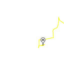
Mode changed to P-GPS
Flight time: 00m 03s
Altitude: 3.9 ft
Home Distance: 2 ft


Map Data
Imagery ©2019 , Bluesky, Getmapping plc, Infoterra Ltd & Bluesky, Maxar Technologies, The GeoInformation Group
[url=]Map Data[/url]Imagery ©2019 , Bluesky, Getmapping plc, Infoterra Ltd & Bluesky, Maxar Technologies, The GeoInformation Group
Imagery ©2019 , Bluesky, Getmapping plc, Infoterra Ltd & Bluesky, Maxar Technologies, The GeoInformation Group
Terms of Use


Map
  Terrain Terrain
Satellite
Labels
| |
HD Flight Player NEW! | Download notifications KML |
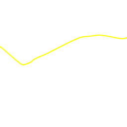
Flight timeAltitude Home DistTypeNotification
A00m 00s0.0 ft0 ftMode[url=]Mode changed to Motors_Started[/url]
B00m 00s0.0 ft0 ftWarning[url=]Your aircraft has entered a Warning Zone (Class D Airspace). Please fly with caution.[/url]
C00m 00s0.0 ft0 ftTip[url=]Setting new Return-To-Home altitude to 50m (164 ft). Data Recorder File Index is 93. Setting new Maximum Flight Altitude to 150m (492 ft)[/url]
D00m 01s0.0 ft0 ftMode[url=]Mode changed to AutoTakeoff[/url]
E00m 02s0.7 ft0 ftTip[url=]Home Point Recorded. RTH Altitude: 50m.[/url]
F00m 03s3.9 ft2 ftMode[url=]Mode changed to P-GPS[/url]
G00m 15s7.2 ft15 ftMode[url=]Mode changed to Sport[/url]
H00m 19s8.2 ft42 ftWarning[url=]Speed Error (repeated 6 times)[/url]
00m 51s231.3 ft59 ft[url=]90% Battery[/url]
I01m 07s342.5 ft127 ftTip[url=]High wind velocity. Fly with caution and land in a safe place ASAP.[/url]
01m 43s358.9 ft325 ft[url=]80% Battery[/url]
J01m 45s358.6 ft351 ftWarning[url=]Compass Error (repeated 4 times)[/url]
K02m 01s359.9 ft664 ftMode[url=]Mode changed to Go_Home[/url]
L02m 01s359.9 ft664 ftTip[url=]Aircraft is returning to the Home Point. Minimum RTH Altitude is 50m. You can reset the RTH Altitude in Remote Controller Settings after cancelling RTH.[/url]
02m 35s359.9 ft1,126 ft[url=]70% Battery[/url]
M02m 41s360.6 ft1,212 ftData Loss[url=]Downlink data connection lost for 2.4 seconds[/url]
N02m 49s354.7 ft1,298 ftWarning[url=]Not Enough Force/ESC Error (repeated 2 times)[/url]
O02m 58s354.3 ft1,389 ftData Loss[url=]Downlink data connection lost for 1 seconds[/url]
03m 00s354.3 ft1,418 ft[url=]66% Battery at maximum distance[/url]
|
|
|


